I
knew this would be a long day, and that perhaps it should have been attempted a
month or two ago, but finding a free weekend these days is sometimes not
trivial. In any case, the ANZAC day weekend loomed and we went for
it.
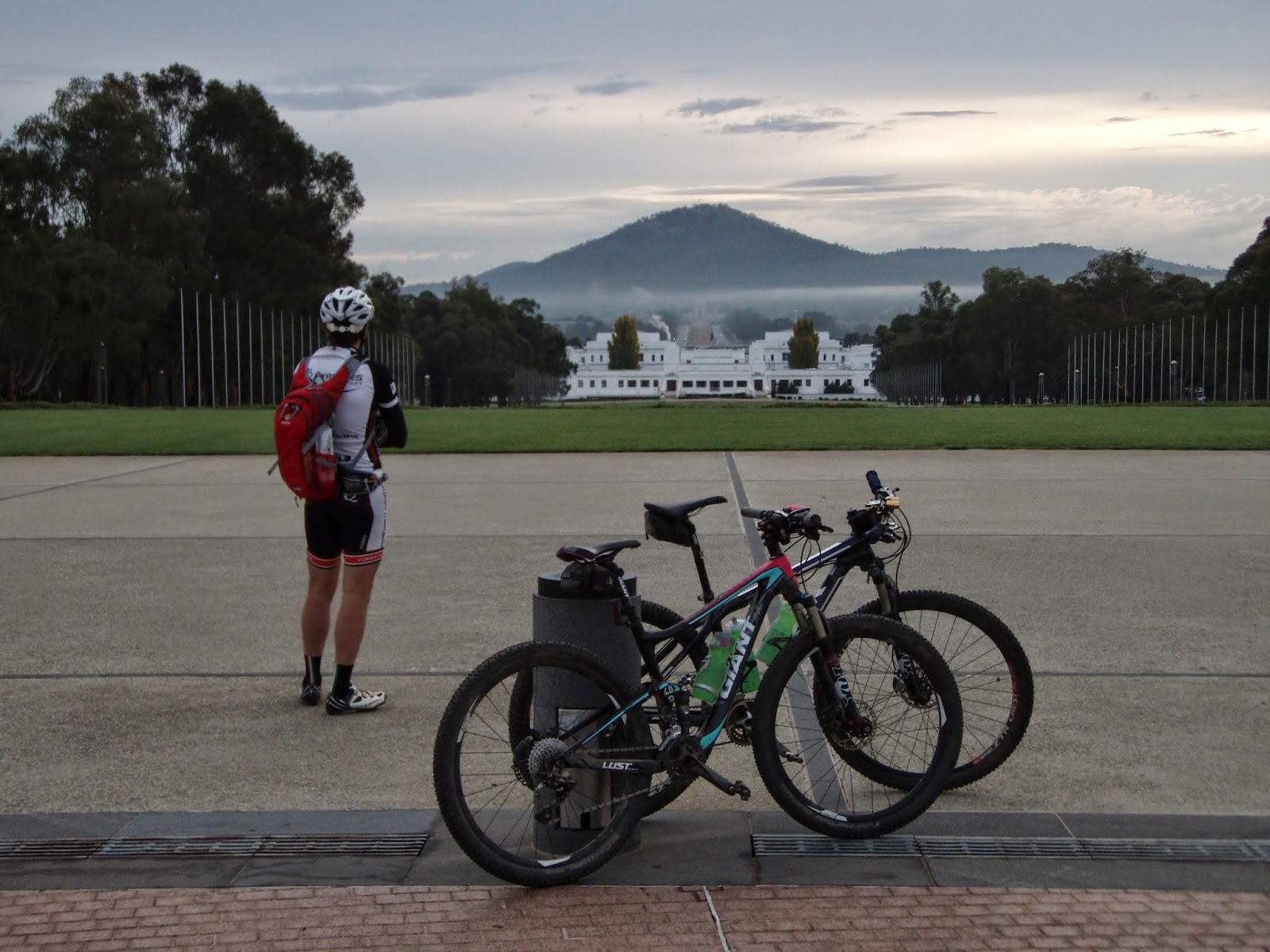
The
Centenary Trail was marked last year in commemoration of Canberra turning
100. Intended as a trail which can be walked in 7 days or ridden in
three, the trail starts at Parliament House, skirts the War Memorial, then soon
has one at the scrubby base of Mt Ainslie before arcing in a wiggly
anticlockwise 145 km loop along the perimeter of the built up areas (and
beyond), before returning one back (eventually) to the flagstaff on the hill.
We
packed the seven PDF trail maps, snacks and a few warmer items into backpacks
and were rolling at 7 am - as early as we could muster even though sun-up was at
6:35. Our hotel was 5 km from the start/end points (the big
flagstaff), so we were always going to be looking at something close to 160 km
for the round trip. I was hoping we’d be
done by sunset at 5:25pm. Not being locals, actually studying the
map would have made things a bit slicker and saved us a good hour due to
navigational hiccups. However,
unsighted, it's hard to know which bits were going to catch us
out. In any case, a good dose of uncertainty adds to the adventure.
The
Centenary Trail does a great job in showcasing some of the best of what the ACT
has to offer, and it doesn't take long before the manicured grandness of spaced
buildings, boulevards and gardens melds into native woodlands, with the fat
tyres rumbling along red earth rural trails in the morning shadows of Mt
Ainslie. Almost collected a few startled Kangas on those first few
bush kilometers.
Thus
far the trail was well marked, and my brain switched off. Sidling
round the base of Ainslie we cruised a bend too far and onto a segment leading
to one of the summit tracks. Such
diversions are intended to be walked only - optional features which
periodically present, and would have been quite obvious had we printed the maps
in colour – OK, or actually studied them. We subsequently crossed the
only other rider we'd seen thus far who immediately recognised me and blurted
my name. What are the chances of that? Alex is a friend
of my brother's and a few years back rode with our team at the
Mont24. After a few minutes chit-chat we parted ways, blindly clawing
over more terrain which was a good deal more punchy than what had passed
before.
Soon
I could see signs of Queanbeyan in the distance and I knew we'd stuffed
up. We retraced about 1.5 kilometers of pinch climb lumpiness (Mudge
not happy) and eventually found the correct line which took us further north
along to the base of Mt Majura (ironically, where Alex was headed in the first
place). 30 minutes lost and we'd only just started!
The
trail meanders north to Mulligans flat, a nature reserve bordering Gungahlin,
where another brain explosion had us miss the pedestrian door in the otherwise
no-nonsense electrified perimeter fence. A bit of boundary skirting
had us back at the magical door (where the fence is first encountered!), and
through. Another 10 min penalty. A handful more times we
had to do a bit of detective work to get back on the scent. Stop to get the map out – that's another
minute gone. Repeat 30 times. Whingeing aside, overall the course was
pretty well marked, although pauses we couldn’t avoid came in the form of
dozens of livestock gates we had to pass bikes over or through during the
course of the day. Again, at 1 min a gate minimum that's another 30-45 minute time
penalty for the day. You can see where this is going.
Our
only other major-league stuff up occurred trying to bridge between the
Arboretum and Stromlo Forest Park, of all places, a segment I've even raced in years
past. Conflicting maps, ambiguous trail markers followed by some
critically defaced markers had us scratching heads. We could see
Stromlo, we just couldn't get to it. The direct option was
disappointingly halted by the Molonglo River. Backtracking we skirting this to
the south which dumped us at an extensively fenced off building site (new
suburb). Anxiety levels were rising but
we eventually picked our way through the fences and blackberry patches to gain the
familiar grounds of Stromlo at about 2:30 pm, still with about 60 km to travel,
but we were back on track, and there were some great trails to come.
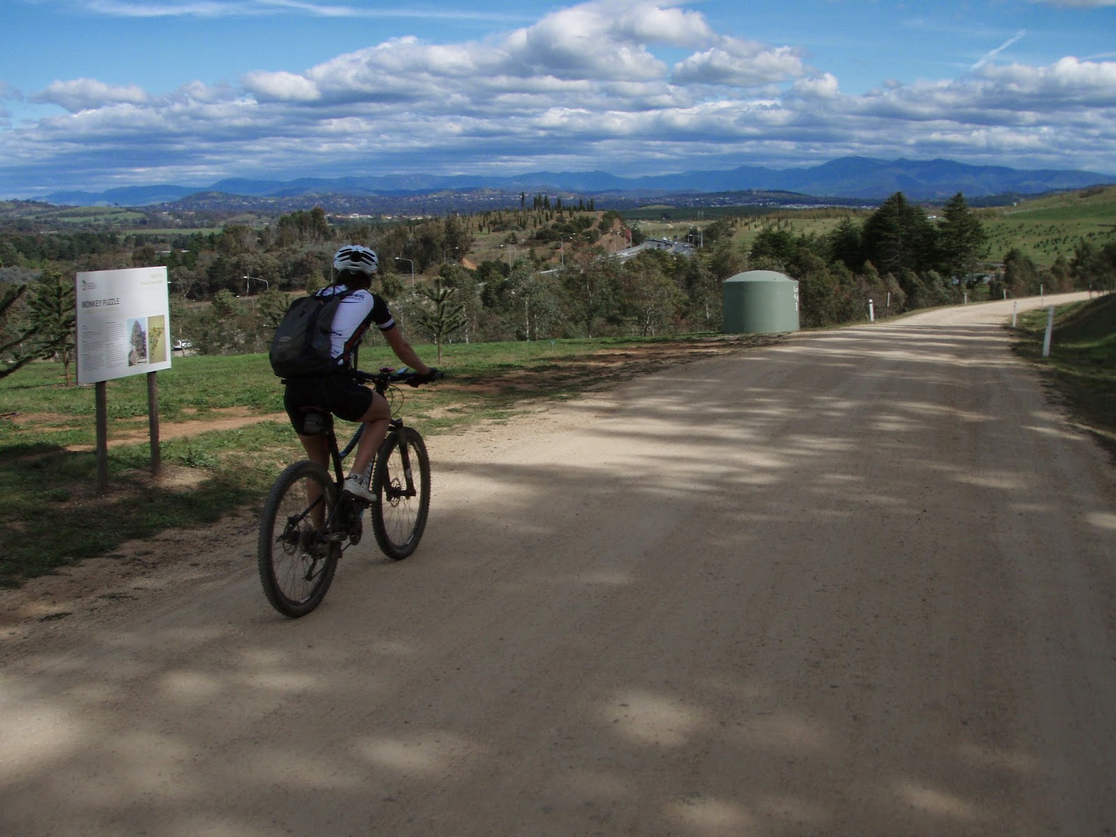
Not
that any of Stromlo's trails would be ridden- that's not the idea of the CT. The
emphasis is on showcasing lesser-known trails and areas, especially the
northern and southern boundaries of the loop. The northern sector
had some terrific single track which led to big-sky vistas and hill-side
traverses, followed by a great descent into the small outpost of Hall, where we
lunched at the post office on kick-A lamingtons and bacon and egg rolls,
although the coffee wasn't much chop (you’ve been warned!). The southern sector
has one descending to and skirting the beautiful Murrumbidgee river, with the
Brindabella ranges as a towering backdrop. Again, terrific single track
with lots of little pinch climbs out to regain civilization at Tuggeranong.
At
“Tuggers” we had out second shop stop, mainly replenishing liquids, (forgetting
to top up at Stromlo) yet still had approx. 30 km to travel with the clock
nudging 4:20. It would be dark in an hour and someone was making
mention of an abandon. I tried to keep
spirits up, yet given that our cumulative average for the day was in the order
of 13 km/hr, at least an hour under lights was on the cards. But we had lights fitted and in theory the
run home was fairly flat.
Fortunately
this turned out to be the case (mostly), mashing along the suburban bike paths
in big gears, losing the trail only once (if you find yourself suddenly in
Chisolm, about-face and go back over the bridge). The final hiccup was grinding up another of
those “walk-only” pinch climbs to the Trig at Isaacs Ridge (great last light
views, BTW), before a sketchy descent and easy underlights traverse around
rabbits, kangaroos, Mt Mugga Mugga and Red Hill. There were just enough markers to guide us
through swanky suburbia back to the Light On The Hill itself. A security guard did the photographic honours
on the back steps before shooing off the premises.
We
cruised back over the bridge and onward to the hotel, bathing in the smugness
that, in spite of numerous stuff ups, we’d burnt the candle at both ends and experienced
a terrific day out, one that has raised Canberra and surrounds another notch or
two in my estimations. Steak at the pub
never tasted so good. According to
Anita’s Garmin the moving time (not a metric I’m a fan of) was 9:20 for approx.
162 km. But door-to-door we were a neat
12 hours. Given that we now know what is
in store and where to go, I know we’ll be back and manage a daylight finish at
the next attempt. Best birds? Toss-up between numerous Scarlet Robins and a
family of Double-bar Finches in the Arboretum.


Think I'm actually starting to enjoy this mountain biking thing!
ReplyDeleteNice one Dave and Anita, persistence pays off. Dave I'm always astonished by your ability to recall the details, places, times, loop backs. I don't think I would be able to navigate such a convoluted route. Great reading. K
ReplyDeleteJust got around to reading this - sounds like a wonderful day out. I remember when mountain biking was about getting lost and discovering new trails (easy with my poor memory) rather than lapping and looping. Nice one! Ben
ReplyDelete